Using remote sensing technology for the monitoring of ocean and coastal habitats
Our oceans are the lifeblood of our planet – but unfortunately, they’re also at great risk. Climate change-related shifts in temperatures can wreak havoc on local marine populations and lead to their extinction. Moreover, overfishing, oil spills along with plastic waste have all led many aquatic species towards near-extinction or endangerment status. One solution for monitoring habitats lies with remote sensing tech like drones that gather data through mounted high-resolution cameras. Satellite imagery proves to be an invaluable tool in studying the Earth’s oceans as it allows for a holistic view of vast terrains.
Observing changes in ocean temperature, currents and sea levels has never been easier thanks to this technology. Moreover, we can identify regions where pollution is rife, or which serve as critical habitats for aquatic creatures. The advantage which satellite imaging has over other methods cannot be overstated – it can provide the access to distant areas that remain out of our reach.
As science continues its course toward developing new resources and expanding our understanding of different environments around us, it is essential to consider how we can best gather useful insights about even very remote regions like Antarctica or the Arctic—the latter demonstrated an increased sensitivity for widespread environmental change each year. In many cases, we turn towards accessible technologies such as satellite imagery which offer valuable tools that make collecting data simpler regardless of how isolated and hazardous a location may be.
Maintaining healthy ocean and coastal ecosystems is an essential part of combating large-scale global problems like climate change or PCB contamination threatening fragile marine food chains at their root but understanding what’s happening beneath the waves can be difficult without persistent research efforts backed by cutting-edge technology solutions like unmanned aerial vehicles (UAVs).
With UAV’s advanced imaging capabilities that far outstrip satellites in capturing detailed imagery, and various sensor options for tracking environmental changes with great accuracy, researchers have more resources at their disposal than ever before. Their real-time capabilities enable scientists to monitor and react efficiently when changes occur within an ecosystem. Compared to traditional research vessels, UAVs are more economical, providing a better option for researchers with limited funding options.
That said, we shouldn’t forget that UAVs have limitations such as range and endurance leading towards smaller areas covered unlike satellites. In addition, UAVs must be operated by highly skilled personnel and are subject to regulations that prohibit certain activities in specific regions. Moreover, weather conditions such as heavy rain or high winds can adversely affect their ability to collect accurate information.
Satellite-based remote sensing technology studies have revealed that it is particularly useful when it comes to observing coastal ecosystems. A study conducted by researchers at Remote Sensing of Environment shows how they monitored toxic algal blooms in the Gulf of Maine using satellite imagery. Experts are raising alarm bells over an increase in blooms across ocean and coastal habitats but suggest solutions may lie in advanced technologies like satellite imagery and unmanned aerial vehicles (UAVs).
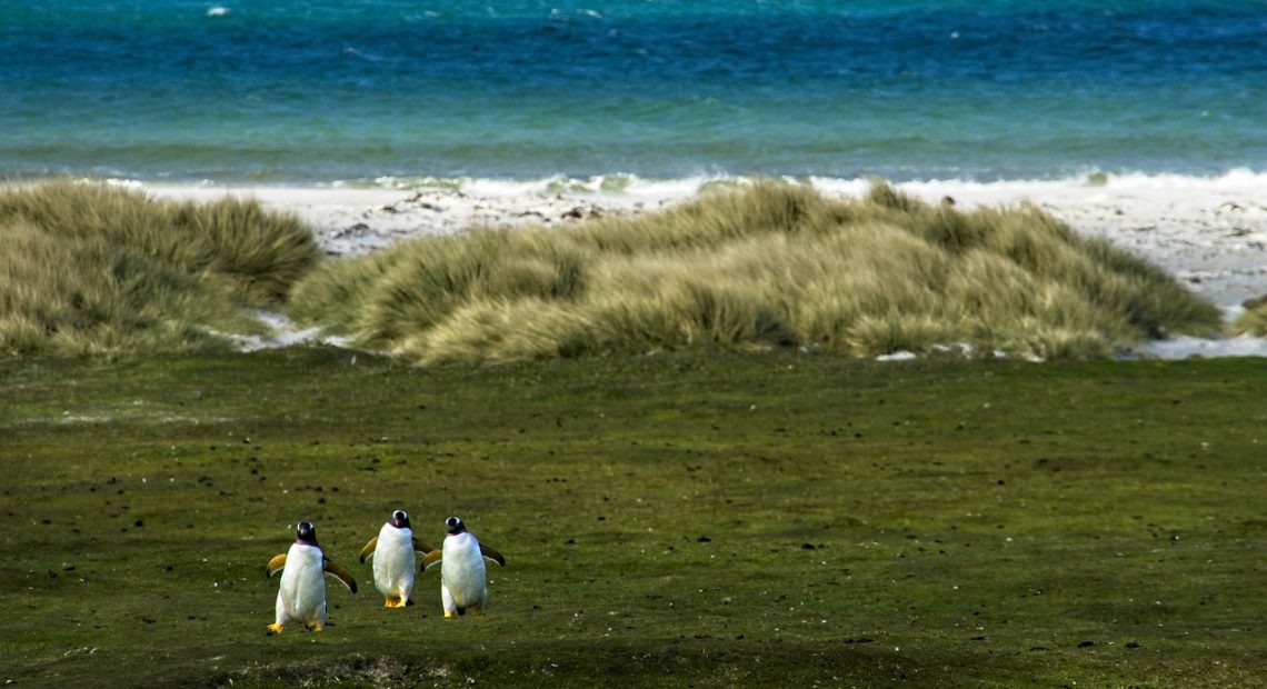
Studies have already shown how these tools can successfully aid conservation work – one project using UAVs captured highly detailed images of seabird colonies in the Falkland Islands for population tracking purposes. The use of remote sensing technology offers significant potential in providing invaluable data on intricate marine systems – despite its downsides.
According to Dr. Karen St Germain from NASA’S Earth Science Division – “Remote sensing has become an essential tool for understanding our planet, and our oceans are no exception.” In effect, remote sensors can enable scientists to scan large swathes of the ocean – both offshore as well as near-shore areas – detect changes within the ecological network, then respond by establishing conservation measures that will safeguard marine life while protecting their habitat simultaneously. Amidst today’s unprecedented environmental pressures, remote sensing technology plays an indispensable role in monitoring and safeguarding our oceans.
Essentially, satellite imaging and UAVs represent a fresh approach for keeping track of massive expanses of oceanic and coastal habitats. The potential of this technology for providing comprehensive data on marine ecological health is boundless. As our oceans continue to face multiple threats, remote sensing devices will no doubt take centre stage in conservation efforts for these vital ecosystems.
Resources
Acoustic Monitoring: An Innovative Approach To Studying Marine Life
Remote Sensing of Ocean and Coastal Environments